
The origin of one of West Ashley’s most travelled roads Wappoo Road.
 Almost everyone who lives in West Ashley crosses or drives this road on a daily basis. But does anyone really ponder the origin of the road or its name?
Step back to when the first people arrived by boat from England and the story begins to unfold. It begins with Wappoo Creek.
Wappoo Creek was originally named Stono Creek when John Culpepper mapped out the area in 1671. Records show that by 1679 it was being referred to as Wappoo Creek. There is the suggestion that some bodies of water where being named to honor the local indigenous population that were here when the English arrived.
The name Wappoo may come from a subgroup of Cusabo Native Americans that populated the creek’s shore. To continue with this the nomenclature, Eliza Lucas Pinckney’s land along the creek was named Wappoo Plantation. In the early 1700s roads were being designed to allow land owners to navigate among their large holdings.
The “Road to the Wappoo Causeway” was one such road that connected the plantations along the west bank of the Ashley to land on James Island. Very early maps show the path from the west bank of the Ashley that turns south at the Graham AME church towards James Island to connect where Wappoo Creek enters the Stono River, thus the “Road to the Wappoo Causeway.”
Fast forward to the early 1900s and the land was changing from agrarian to suburban. Enough young families had moved to “the country” that it was necessary to create a centrally located school for the Parish. In the 1930s, when the decision was made to build St Andrew’s Parish High School, Wappoo Road was the chosen site as it was considered to be the center of the Parish. Not only was it the geographic center but it was also a hub of activity.
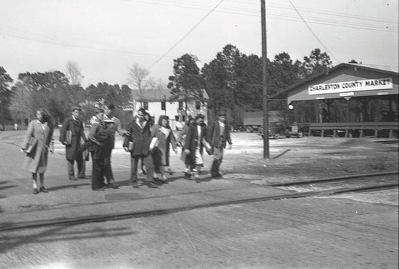
The Atlantic Coast Line RR and the Seaboard Airline RR crossed just a bit south of Wappoo Road and was known as Dupont Crossing. This moniker was used for the area and everyone understood that this name defined the greater location around Wappoo Road. The Charleston County Vegetable Market had been built alongside the Seaboard Airline RR tracks that crossed Wappoo Road. Transportation of farm goods to market happened regularly at this site. (Today the Seaboard Airline RR tracks have been converted to the West Ashley Bikeway).
Gas stations run by Bootle, Dupont and Whaley occupied three of the corners – two of the gas stations had grocery stores and one had a diner. All were hangouts for locals, students, hunters and business people. Many pictures, stories, and local history revolve around Dupont Crossing and Wappoo Road. It was the center of the community and its importance was felt by all.
This importance was underscored on numerous occasions, but one that is very familiar to locals who lived in West Ashley in 1955 was the destruction of the bascule portion of the Ashley Memorial Bridge when the Fort Fetterman lost control trying to maneuver and crashed into the bridge.
Everyone on the west bank of the Ashley River was now disconnected from the peninsula and a convenient route to the Naval Yard. This was important because many of the residents were employed there. The Seaboard Airline RR was more of a cargo rail than a passenger rail but during this period of time the railroad stepped up and transported people from Dupont Crossing at Wappoo Road across the river, mostly for large gatherings like ball games.
Once the North Bridge was complete, it was necessary to connect that part of the Parish from the bridge to the various neighbors. Sam Rittenberg Boulevard was planned and the original design was to connect to Wappoo Road and then onto Highway 17. As we now know someone thought better of that plan. Today Sam Rittenberg Boulevard connects directly to Highway 17.
Stories about Wappoo Road? Contact Donna Jacobs at westashleybook@gmail.com.


